Groundwater Monitoring
Why Monitor Groundwater?
It is hard to manage what you don't measure - groundwater is one of those elusive things that is relatively hard to measure, but with the use of groundwater level monitoring equipment, water table depth measurements can be taken on an ongoing basis to understand what is going on underground. This provides a means to observe if water levels are changing over time, to get early warning if supply may be impacted, and to better inform development that occurs in our region. The DWWP supported two initiatives as a part of this project, a collaboration to expand the B.C. Groundwater Observation Well Network within the region and the creation of the RDN Volunteer Observation Well Network.
Provincial Groundwater Observation Well Network
To track groundwater levels across B.C., the provincial government maintains and manages a network of wells that are dedicated to continuous monitoring of aquifer levels called the Provincial Groundwater Observation Well Network (PGOWN). Groundwater level monitoring equipment in these wells collects data on mapped aquifers within our region to increase the understanding of whether aquifers are in decline, stable, or on the rise (Figure 1).
In 2011, the DWWP program partnered with the province and the Geological Survey of Canada to expand the PGOWN in our region. With the assistance of grant funding, 16 wells were added to the network in three phases between 2011 - 2013. Some of these were newly drilled or cored, some were unused wells donated by private well owners. The total number of dedicated B.C. Observation Wells in the RDN is now 35 (Figure 2).
For well water level graphs and well specific information, see the Interactive Map here. To graphically view the long-term trends visit the provincial website here.
Further details about this project can be found in the Ground Water Canada article here.
RDN Volunteer Observation Well Network
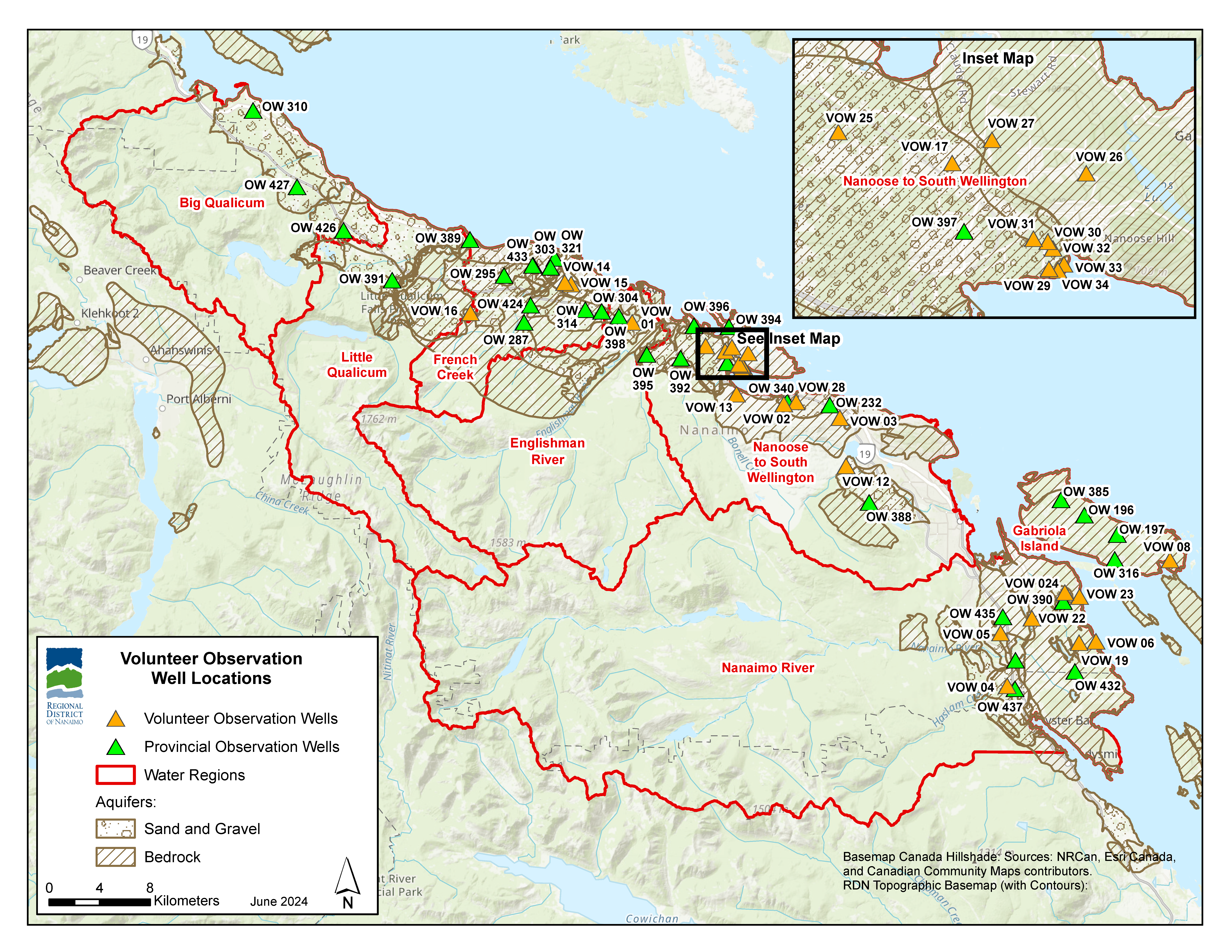
To expand groundwater level data collection in our region beyond the provincial Observation Wells, 31 private well owners volunteered to have groundwater level monitoring equipment (pressure transducers) installed in their wells. The transducers record level data every 15 minutes; the data is downloaded by DWWP staff four times per year. Fourteen of the loggers measure conductivity, to track saline (saltwater) intrusion potential in coastal wells. The monitoring of volunteer wells began in the spring of 2013, with expansions occurring in 2015, 2016, and 2017. It takes a minimum of 5 - 10 years of data collection to begin to discern long-term trends from the information gathered. Since 2020, the RDN has supported annual pre-summer water level analysis reports. Figure 3 below shows the sites included in the 2022 analysis.
Thank you to our volunteers!
Annual Groundwater Level Analysis Reports
- Regional Groundwater Level Analysis Pre-Summer 2020
- Regional Groundwater Level Analysis Pre-Summer 2021 (MEMO) + Tables and Graphs (APPENDICES)
- Regional Groundwater Level Analysis Pre-Summer 2022 (MEMO) + Tables and Graphs (APPENDICES)
- Regional Groundwater Level Analysis Pre-Summer 2023 (MEMO) + Tables and Graphs (APPENDICES)
- Regional Groundwater Level Analysis Pre-Summer 2024 (MEMO) + Tables and Graphs (APPENDICES)
If you are interested in volunteering your well for monitoring groundwater levels, please contact watermonitoring [at] rdn.bc.ca (watermonitoring[at]rdn[dot]bc[dot]ca).
For additional information on watersheds in the RDN visit www.rdn.bc.ca/dwwp-reports.
Figure 1: Provincially mapped aquifers within the RDN (provided by Waterline Resources Inc for the 2020 Pre-summer water level analysis). 
Figure 2: Phased expansion of the Provincial Groundwater Observation Well Network within the RDN (2011 - 2013).
Figure 3: PGOWN and VOW monitoring sites included in the 2024 Regional Groundwater Level Pre-Summer Analysis.